https://mapdesign.ro/en/land-surveying-projects-cadastre-photogrammetry/
Land surveying projects
2,614 projects.
Over 3,200 documentation packages.

Every dot is a completed project.
Since 2005, in Timișoara, Timiș County and across Romania.

Request a quote →

Every new project becomes a dot on this map.

1,492
Continued projects
162
Towns and villages
11
Counties
21
Years of experience

Our relationship with clients continues after the first project.

21 years of experience · 2,614 projects
1,492 projects continued beyond the first one
Request a quote
Featured projects
Land surveying projects: Vila International, Timișoara — topographic documentation approved by the cadastre office, measured with total station and GNSS — Map DesignHouses and landCadastre office approvals
Vila International, Timișoara
Topographic plan of the buildings, courtyard and park (2026)
Timișoara, Timiș County · 2026
The building, opened in 1968 as an official guest residence, is a listed historic monument. It served as a state guest house in the communist …
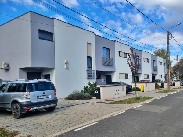
Five terraced houses, Timișoara — cadastre and land registry documentation, measured with total station and GNSS — Map DesignApartment buildingsLand registry registrations and updates
Five terraced houses, Timișoara
Topographic survey of the original property (2016)
Timișoara, Timiș County · 2016-2022
The client bought a property and wanted to make it pay by developing the site. We were involved at every stage over six years. It began with t…
Metropolitan Cathedral, Timișoara — plot subdivision documentation, measured with total station and GNSS — Map DesignChurches and monumentsPlot subdivisions and mergers
Metropolitan Cathedral, Timișoara
Subdivision documentation (2017)
Timișoara, Timiș County · 2017
The cathedral, built between 1936 and 1940, stands on plot number 1 of the Șarmeș plan, and Cathedral Park is plot number 2 — a position that …
Park in the Triaj area, Reșița — drone photogrammetry and 3D model, measured with GNSS — Map DesignSchools, town halls and public spacesPhotogrammetry and 3D models
Park in the Triaj area, Reșița
Topographic survey with GNSS and drone (2024)
Reșița, Caraș-Severin County · 2024
Reșița is being modernised. In the Triaj area, on expropriated land, a park is being laid out next to the future county hospital. The land was…
Hydropower plants on the Bârzava, Reșița — engineering surveying, measured with total station and GNSS — Map DesignRoads, water and utilitiesEngineering surveying
Hydropower plants on the Bârzava, Reșița
3D measured survey and construction site surveying — Grebla, Breazova, Crăinicel (2012)
Reșița and Văliug, Caraș-Severin County · 2012-2013
Along the Bârzava river stand four buildings that housed old small hydropower plants, now under rehabilitation. We made 3D measured surveys of…
București Sud electrical substation — engineering surveying, measured with total station and GNSS — Map DesignIndustrial buildingsEngineering surveying
București Sud electrical substation
3D topographic survey of the work area (2014)
Bucharest · 2014-2016
For the upgrade of the București Sud electrical substation, the project needed exact survey data, both horizontally and in height. We surveyed…
Systematic cadastre, Lăpușnicu Mare — cadastre and land registry documentation, measured with drone, GNSS and total station — Map DesignOther projectsLand registry registrations and updates
Systematic cadastre, Lăpușnicu Mare
First contract with the town hall — four sectors outside the built-up area (2018)
Lăpușnicu Mare, Caraș-Severin County · 2018-2026
Since 2018 the commune of Lăpușnicu Mare has been registering its properties in the land registry through the National Cadastre and Land Regis…
Diocesan Centre and Metropolis of Banat, Timișoara — engineering surveying, measured with total station and GNSS — Map DesignChurches and monumentsEngineering surveying
Diocesan Centre and Metropolis of Banat, Timișoara
Land registry update — rear property (2016)
Timișoara, Timiș County · 2016-2022
The Archdiocese of Timișoara bought the property behind the Diocesan Centre of the Metropolis of Banat and started a project to rehabilitate a…
«Louis Țurcanu» Children's Hospital, Timișoara — cadastre and land registry documentation, measured with total station and GNSS — Map DesignSchools, town halls and public spacesLand registry registrations and updates
«Louis Țurcanu» Children's Hospital, Timișoara
Topographic and cadastral documentation for the certificate of existing buildings (2014)
Timișoara, Timiș County · 2014-2026
In 2014 the hospital asked for newly built structures in its courtyard to be registered. We surveyed the grounds and prepared the topographic …
Solar park, Voiteg — drone photogrammetry and 3D model, measured with GNSS — Map DesignIndustrial buildingsPhotogrammetry and 3D models
Solar park, Voiteg
Drone topographic survey (2024)
Voiteg, Timiș County · 2024-2025
The owner of a solar park wanted to build a second park next to it, producing electricity alongside the first. The land was under crops at the…
Ineu Fortress — topographic survey, measured with total station and GNSS — Map DesignChurches and monumentsTopographic surveys
Ineu Fortress
Topographic plan of the site (2011)
Ineu, Arad County · 2011
Ineu Fortress, built in its present form between 1645 and 1652, was about to enter a rehabilitation and restoration project, and the design fi…
Private property, Timișoara — cadastre and land registry documentation, measured with total station and GNSS — Map DesignHouses and landLand registry registrations and updates
Private property, Timișoara
Property data update and land registry registration (2014)
Timișoara, Timiș County · 2014-2026
We regularised the cadastre status of a private property in Timișoara. In 2014 we updated the property data and registered it in the land regi…
Apartment buildings, Giroc — cadastre and land registry documentation, measured with total station and GNSS — Map DesignApartment buildingsLand registry registrations and updates
Apartment buildings, Giroc
Documentation for the building permits (2016 – 2018)
Giroc, Timiș County · 2016-2018
A developer bought several plots in Giroc and built a number of apartment buildings there. For this residential development we carried out the…
Church, Dobrești — drone photogrammetry and 3D model, measured with total station and GNSS — Map DesignChurches and monumentsPhotogrammetry and 3D models
Church, Dobrești
Topographic survey (2024)
Dobrești, Timiș County · 2024
The monastery church in Dobrești is recent: the foundation stone was laid in 2005 and work has continued since. The survey was needed for fitt…
Roads and water networks, Lăpușnicu Mare — topographic documentation approved by the cadastre office, measured with total station, GNSS and drone — Map DesignRoads, water and utilitiesCadastre office approvals
Roads and water networks, Lăpușnicu Mare
Topographic surveys for the roads and the water network (2016 – 2024)
Lăpușnicu Mare and Moceriș, Caraș-Severin County · 2017-2024
Our work with the town hall of Lăpușnicu Mare began in 2016 and continued through a series of projects until 2024. It included topographic sur…
Historic centre, Ciacova — topographic survey and 3D model, measured with total station and GNSS — Map DesignSchools, town halls and public spacesTopographic surveys
Historic centre, Ciacova
Topographic survey — the square and the Cula (2015)
Ciacova, Timiș County · 2015-2025
We surveyed the whole historic centre of Ciacova — the square, the park around the administrative palace, the Cula, a tower from the late 14th…
Electrical substation, Brad — engineering surveying, measured with total station and GNSS — Map DesignIndustrial buildingsEngineering surveying
Electrical substation, Brad
Topographic plan of the compound (2025)
Brad, Hunedoara County · 2025
The substation was due for an upgrade. We surveyed it in two days, together with the topographic features around it, with the equipment live —…
Șoimoș Fortress, Lipova — topographic survey, measured with total station and GNSS — Map DesignChurches and monumentsTopographic surveys
Șoimoș Fortress, Lipova
Topographic survey (2011)
Șoimoș, Arad County · 2011
The restoration project for Șoimoș Fortress, first documented in 1278, needed a topographic survey of the ground, the walls and the façades. W…
Traditional farmstead, Austria — topographic survey, measured with total station — Map DesignOther projectsTopographic surveys
Traditional farmstead, Austria
Topographic survey (2010)
Unterfrauenhaid, Austria · 2010
A Romanian owner living in Austria wanted to rebuild his parents-in-law's farmstead, keeping the corn crib and the other features of the yard.…
Fabric Synagogue, Timișoara — cadastre and land registry documentation, measured with total station and GNSS — Map DesignChurches and monumentsLand registry registrations and updates
Fabric Synagogue, Timișoara
Topographic survey (2024)
Timișoara, Timiș County · 2024
We surveyed the synagogue and its grounds. The survey showed that the previously approved property boundary was wrong, so a documentation corr…
Art Museum — Baroque Palace, Timișoara — cadastre and land registry documentation, measured with total station and GNSS — Map DesignSchools, town halls and public spacesLand registry registrations and updates
Art Museum — Baroque Palace, Timișoara
Topographic survey of the two properties (2025)
Timișoara, Timiș County · 2025
We surveyed two linked properties serving the Art Museum: the Baroque Palace, built between 1752 and 1754, and the building on Florimund Mercy…
Continental industrial site, Sibiu — engineering surveying, measured with total station and GNSS — Map DesignIndustrial buildingsEngineering surveying
Continental industrial site, Sibiu
Topographic survey of the whole compound (2015)
Sibiu, Sibiu County · 2015
For the extension of the existing industrial site, we surveyed the whole industrial complex while it was in operation. The survey covered the …
Residential development, Dudeștii Noi — topographic documentation approved by the cadastre office, measured with total station and GNSS — Map DesignHouses and landCadastre office approvals
Residential development, Dudeștii Noi
Topographic survey with static GNSS observations (2017)
Dudeștii Noi, Timiș County · 2017-2024
In Dudeștii Noi, in 2017, we surveyed five hectares of land with static GNSS observations, because the cadastre office requires high accuracy …
Apartment complex, Dumbrăvița — apartment division documentation, measured with total station and GNSS — Map DesignApartment buildingsApartment divisions
Apartment complex, Dumbrăvița
Land registry update (2015)
Dumbrăvița, Timiș County · 2015-2020
Over time, an architecture office bought several plots on which it made property investments. Buildings with shops on the ground floor and apa…
Wooden church, Sartăș — drone photogrammetry and 3D model, measured with total station and GNSS — Map DesignChurches and monumentsPhotogrammetry and 3D models
Wooden church, Sartăș
Topographic survey and measurements of the façades and cemetery (2024)
Sartăș, Alba County · 2024
The wooden church in Sartăș, built before 1780, is entering conservation and restoration, required by the urban planning certificate issued by…
Bega water treatment plant, Timișoara — engineering surveying, measured with total station — Map DesignRoads, water and utilitiesEngineering surveying
Bega water treatment plant, Timișoara
Construction site surveying — setting out the steel structure (2025 – 2026)
Timișoara, Timiș County · 2025
Aquatim is building a new water treatment plant on the bank of the Bega. For the erection of the steel structure we marked the positions of th…
Luncanii de Sus Monastery — engineering surveying, measured with total station and GNSS — Map DesignChurches and monumentsEngineering surveying
Luncanii de Sus Monastery
Topographic survey of the site (2019)
Luncanii de Sus, Timiș County · 2019-2023
The monastery church at Luncanii de Sus, built of timber between 2001 and 2006, began to lean because of the unstable ground beneath it. We st…
ASTRA Museum, Sibiu — topographic survey, measured with total station and GNSS — Map DesignSchools, town halls and public spacesTopographic surveys
ASTRA Museum, Sibiu
Topographic survey (2016)
Sibiu, Sibiu County · 2016-2017
The ASTRA Museum in Sibiu, an open-air village museum, has modernised its grounds. We prepared the topographic and cadastral documentation in …
Industrial buildings, Giarmata — engineering surveying, measured with total station and GNSS — Map DesignIndustrial buildingsEngineering surveying
Industrial buildings, Giarmata
Construction site surveying — Continental building (2014)
Giarmata, Timiș County · 2014-2022
In the industrial area at the entrance to Giarmata from Dumbrăvița, several industrial buildings have been built. For three of them we provide…
Wooden church, Cebza — drone photogrammetry and 3D model, measured with total station and GNSS — Map DesignChurches and monumentsPhotogrammetry and 3D models
Wooden church, Cebza
Topographic survey (2024)
Cebza, Timiș County · 2024
The wooden church in Cebza, built in 1758 and listed as a historic monument, stands in the village cemetery. We surveyed it for the works requ…

Photo to be chosen

Stages
    What the client received
    Equipment used
    Loading the 3D model…
    Rotate with your finger or mouse · zoom with two fingers or the scroll wheel

    The Map Design portfolio: projects completed from 2005 to today

    Land surveying, cadastre and photogrammetry: 2,614 projects in 11 counties

    This page shows the land surveying projects Map Design has completed from 2005 to today, including cadastre and photogrammetry: 2,614 projects in 162 towns and villages across 11 counties, with over 3,200 documentation packages prepared. Our office is in Timișoara, and most of our projects are in western Romania. Of these, 1,492 are on sites we returned to in later years, at the client’s request, for the next stage: further surveys or the cadastre documentation the property needed. The map shows the approximate position of each project and, with it, the area we cover.

    Land surveying projects

    Our land surveying projects have included topographic surveys, measured surveys of architecture and heritage buildings, setting out and construction site surveying, carried out with total stations and GNSS receivers in RTK. We have also checked buildings for verticality. At the Diocesan Centre of the Metropolis of Banat we worked from the survey of the grounds to the last checks on site. Our engineering surveying projects include the București Sud and Brad electrical substations, the small hydropower plants on the Bârzava river and the Bega water treatment plant in Timișoara.

    Cadastre projects

    Our cadastre projects range from registering a single apartment in the land registry to the systematic cadastre of an entire commune: in Lăpușnicu Mare we have been working since 2018 under the National Cadastre and Land Registration Programme. We have resolved cases where the land registry no longer matched the land, and corrected errors in older documentation, as with the wooden church in Cebza. For a group of five houses in Timișoara we stayed with the same client through every stage, from the first survey to the division into apartments. The documentation was signed by surveyors licensed by ANCPI.

    Photogrammetry projects

    For photogrammetry we use the DJI Mavic 3 Enterprise RTK drone, with ground control points measured by GNSS, and produce orthophotos and 3D models with an accuracy better than 2 cm. On historic monuments we applied photogrammetry to the wooden churches in Sartăș and Cebza. In Lăpușnicu Mare we used it for the water network and for the systematic cadastre, processing over 5,000 images.

    Total station on a tripod, topographic survey

    Land surveying

    We prepare topographic plans for design and permitting: topographic surveys, setting out and levelling, with every detail the designer needs — elevations, utility networks, neighbouring plots and buildings. The topographic plan is the basis of every well-started project.

    Request a surveying quote
    Map with a marker — locating the property

    Cadastre

    We prepare cadastre documentation for the land registry: first registration, plot subdivisions and mergers, data updates and error corrections. We take each file from the survey to approval by the cadastre office, and we check the documents before we promise anything.

    See our cadastre services
    Licensed surveyor equipped for field work

    Construction surveying

    We are your site surveyor, from site handover to the end of construction: we set out, check and monitor, so the building goes up exactly where and how it was designed.

    Request a quote
    Photogrammetry

    Photogrammetry

    From drone flights we produce orthophotos, topographic maps and 3D models — accurate data for large areas, urban planning, land monitoring and cadastre. Where a conventional survey would take weeks, a flight does it in hours.

    Request a photogrammetry quote
    SCAME
    Fabrica de proiecte
    voestalpine
    Archdiocese of Timișoara — Metropolis of Banat
    Biserici Înlemnite
    Biserici Înlemnite
    Atelierul Non-Formal de Planificare Spațială (ANF), architecture firm
    Google

    Client reviews

    ★★★★★★★★★★4.8 out of 5 · 26 Google reviews
    raluca georgescu
    raluca georgescu
    ★★★★★

    Profesionalism, grija la detalii, suflet bun, implicat, seriozitate, rezultate excepționale, oferă soluții in situații complicate. Îl recomand cu toată inima, mulțumesc!!!

    Cosmin Vladut Manolache
    Cosmin Vladut Manolache
    ★★★★★

    Oameni faini.Seriozitate și colaborare ok .Recomand.

    Anca Atudorei
    Anca Atudorei
    ★★★★★

    I highly recommend this company! From start to finish, the entire team was professional, punctual, and straightforward.

    daniel achim
    daniel achim
    ★★★★★

    ​Servicii excelente și servicii de top! Cei de la Map Design Timișoara sunt extrem de serioși, rapizi și amabili. Au dat dovadă de mult profesionalism și implicare. Recomand cu drag!

    Laura Chis
    Laura Chis
    ★★★★★

    Sunt multumita de serviciile Map Design: comunicare rapida si simpla, explicatii clare si rezolutie rapida.

    Beatrice Borbely
    Beatrice Borbely
    ★★★★★

    Super profesioniști și prompți. Recomand!

    Paola Bozga
    Paola Bozga
    ★★★★★

    O firma serioasa și prompta. Va mulțumesc!

    Rafaela Hasna-Bolba
    Rafaela Hasna-Bolba
    ★★★★★

    Foarte mulțumită de serviciile oferite de Map Design. O echipă tânără, dinamică și serioasă! Recomand cu încredere!

    hasna cristinel
    hasna cristinel
    ★★★★★

    Super profi oamenii! Recomand cu încredere! Rezolvare fără bătăi de cap!

    Land surveying, cadastre and photogrammetry projects: questions and answers

    Find out more about our projects

    What does the project map show?▸
    The map shows the approximate position of the land surveying, cadastre and photogrammetry projects Map Design has completed from 2005 to today. Projects without an exact position are grouped by their town or village. The colour shows the subject: houses and land, apartment buildings, churches and monuments, schools, town halls and public spaces, industrial buildings, roads, water and utilities, gravel pits and quarries.
    What are “continued projects”?▸
    These are projects on sites we returned to in later years, at the client's request, for the next stage: further surveys or the cadastre documentation the property needed.
    Which photogrammetry and 3D model projects have you done?▸
    With the DJI Mavic 3 Enterprise RTK drone we have produced orthophotos and 3D models with an accuracy better than 2 cm. Our photogrammetry projects include the wooden churches in Sartăș and Cebza, the water network and the systematic cadastre in Lăpușnicu Mare, where we processed over 5,000 images, and the park in the Triaj area of Reșița.
    Have you worked on historic monuments?▸
    Yes. The projects on the map include Șoimoș Fortress, Ineu Fortress, the Metropolitan Cathedral, the Fabric Synagogue and the Baroque Palace in Timișoara, the ASTRA Museum in Sibiu, the wooden churches in Sartăș and Cebza and the historic centre of Ciacova.
    Which infrastructure and industrial projects have you done?▸
    We have carried out engineering surveying at the București Sud electrical substation, the Brad substation, the small hydropower plants on the Bârzava near Reșița and the Bega water treatment plant in Timișoara. The map also shows the roads and water networks in Lăpușnicu Mare, the solar park in Voiteg, the industrial buildings in Giarmata and the Continental industrial site in Sibiu.
    Where do you work?▸
    Most of our projects are in Banat, especially in Timiș County, and elsewhere in western Romania: Caraș-Severin, Arad and Hunedoara. We have also worked in Bucharest, Sibiu, Alba, Brașov, Harghita and Mehedinți, and in 2010 on a project in Austria.
    How do I request a quote for a similar project?▸
    Preparing a quote is free, and you get an answer within 24 hours. For complex projects we discuss the technical requirements with the client before sending the quote, so that it fits the project. You can reach us by phone at +40 749 031 223, on WhatsApp, at office@mapdesign.ro or through the quote form.

    A land surveying,
    cadastre or
    photogrammetry project?

    For a project like the ones on this map, preparing a quote is free and you get an answer within 24 hours: by phone at +40 749 031 223, on , at office@mapdesign.ro or through the quote form. For complex projects, we discuss the technical requirements with the client before sending the quote, so that it fits the project.

    Request a tailored quote
    Surveying, Cadastre, Photogrammetry, Construction Surveying
    Close Search Window